Is this also a map?
A Map of Tibet in the Form of a Female Demon
20th century
This map in the shape of a female demon represents the Tibetan worldview.
It depicts the legend of how Tibet became a Buddhist country. Temples are built in various places corresponding to the joints of the hands and feet of a female demon lying on the Tibetan plateau, just like nails restraining her, to prevent her from causing disasters.
Norbulingka Palace collection

Tabula Peutingeriana
ca. 4th century (13th-century copy reproduced in 1887)
A map of the Roman Empire and its surroundings from around the 4th century, showing Roman roads and cities and inns alongside them, as well as mountain ranges, forests, rivers, etc. The standardized map symbols and the mention of distances between cities, among other elements of the map, suggests that it was used by people to get around. (Length: 6.75 m, Height: 35 cm) Austrian National Library collection
(Overview)

(Detail)

Ptolemy World Map
ca. 2nd century (mid-15th-century copy)
Map created by the Greek mathematician PTOLEMY.
In order to depict the spherical earth on a flat surface, the equidistant conic projection method was used, and the concept of latitude and longitude was also introduced.
British Library collection

Hereford Mappa Mundi
ca. 1290
The largest remaining Mappa Mundi (world maps drawn in medieval Europe).
It was painted on fine vellum (calf skin) using red and black ink and gold leaf.
(Width: 133 cm, Height: 158 cm) Hereford Cathedral collection

Waldseemüller's World Map
1507
World map created by German cartographer Martin WALDSEEMÜLLER. The new continent of America and the Pacific Ocean were included in a map for the first time in the history of maps, which greatly changed the perception of Europeans.

The World in a Cloverleaf
1581
This map, created by German pastor Heinrich BÜNTING, shows three regions of the world (Europe, Asia, and Africa) represented by clover leaves with Jerusalem at their center. It represents a Christian worldview centered on Jerusalem.

Gyoki's map
"Ancient Encyclopedia (copy)" (Gyoki-zu "Shugaisho (Shahon)"), from 1656
This is an ancient map of Japan. Although it is thought that a monk from the Nara period named GYOKI created this map, no copy of the original map exists at present and its authenticity is unknown. However, this map was used as the prototype for Japanese maps for a long time, and it is believed that all Japanese maps before the appearance of NAGAKUBO Sekisui and INO Tadataka in the mid-Edo period were based on this Gyoki's map.

Saliba's map of the cosmos
ca. 1593
Created by Antonio SALIBA, Maltese cartographer, astronomer, theologian and philosopher. Eight elemental spheres are drawn in concentric circles. Space is at the center followed by the earth's subsurface, surface, map, some natural phenomena and, at the outermost circle, the fire and light of the highest heaven.

Iceland's landscapes and legendary monsters
1598
Map of Iceland as depicted in the "Stage of the World" (Theatrum Orbis Terrarum) by ORTELIUS, the world's first modern atlas. It depicts the landscape of the time, including rivers, mountains, fjords, glaciers, and human settlements, as well as the eruption of Mount Hekla and legendary sea monsters.

Road from Whitby to Durham
from "Britannia", 1675
Part of a road map published by Scottish translator John OGILBY. The scroll-shaped map is arranged in strips.

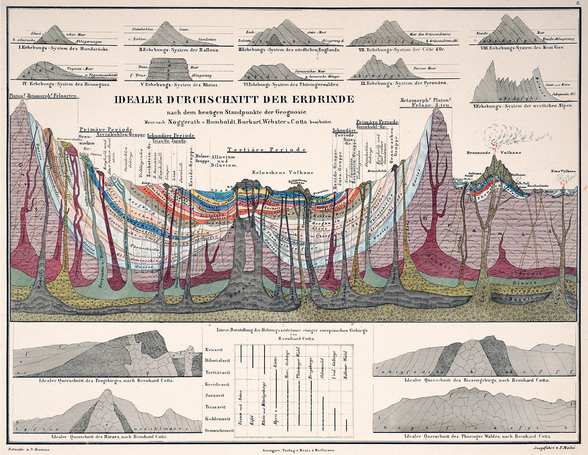
Ideal Section of a Portion of the Earth's Crust
Alexander VON HUMBOLDT, 1851
A color-coded plate showing the composition of the earth's crust, published in the work "Cosmos (Kosmos)" by HUMBOLDT, a German geographer who is regarded as the founder of modern geography.
Italy & England
from "Geographical Fun", 1869
A series of humorous depictions of various country shapes.


Sugoroku, forward to Ise and Kyoto from Edo (Sangu jokyo dochu ichiran sugoroku)
UTAGAWA Hiroshige, 1857
An ukiyoe painting depicting roads and inns in vivid multicolored prints. Not only the inns but also the roads between them are depicted from a bird's eye view, and the topography of the roads and the slopes' variations are skillfully drawn with emphasis.

Jerry's Map
Jerry GRETZINGER, 2016
Collage work by an American folk artist. It is a combination of A4-sized panels which continue to be updated and expanded on a daily basis. There are over 3,200 panels in total.

The Earth
MATSUDA Koichi, 2015
MATSUDA is a painter from Wakayama Prefecture. He has visited many places around the world and paints world heritage sites and spectacular landscapes as motifs with a unique method of expression, hoping to "create a spirit of peace that connects people through painting." For several years since 2011, he has made a painting of the earth every year, expressing in it the feelings and impressions he felt while traveling around the world.

- Current page: page 1
- 1 / 1
The issue this article appears
No.64 "Map"
Maps invite people into the unknown, and people get thrilled when presented with one―a simple sheet of paper.
From maps carved into rocks and historically ancient maps used in old times, to digital maps made by satellite in the modern era, we humans have been perceiving the world through a variety of maps.Not only do they help us visualize the world’s shape and overall appearance, but sometimes imaginary worlds are also constructed based on them.
In this issue showcasing various maps, we examine how people have been trying to view the world and what they are trying to see.In the Obayashi Project, we took on the challenge of deciphering and reconstructing in three dimensions a fictional city map called the Hashihara Castle Town Map (Hashiharashi Joka Ezu) drawn by Kokugaku scholar MOTOORI Norinaga when he was nineteen years old.
(Published in 2025)
-
Gravure: Is this also a map?
- View Detail
-
What Is a Map?
MORITA Takashi
(Professor Emeritus, Hosei University) - View Detail
-
The Frontiers of Maps: From the Present to the Future
WAKABAYASHI Yoshiki
(Professor Emeritus, Tokyo Metropolitan University) - View Detail
-
Visible World, Invisible World
OTA Akio
(Professor, Department of Visual Communication Design, College of Art and Design, Musashino Art University) - View Detail
-
The Dreams and Solitude of a Youth Who Drew Maps
YOSHIDA Yoshiyuki
(Honorary Director, Museum of Motoori Norinaga) - View Detail
-
OBAYASHI PROJECT
Deciphering the Hashihara Castle Town Map: The Imaginary Town of MOTOORI Norinaga
Speculative Reconstruction by Obayashi Project Team
- View Detail
-
FUJIMORI Terunobu’s “Origins of Architecture” Series No. 15: Japanese Datum of Leveling Monument
FUJIMORI Terunobu
(Architectural historian and architect; Director, Tokyo Metropolitan Edo-Tokyo Museum; and Emeritus Professor, University of Tokyo) - View Detail
-
Interesting Facts About Maps
- View Detail