Interesting Facts About Maps
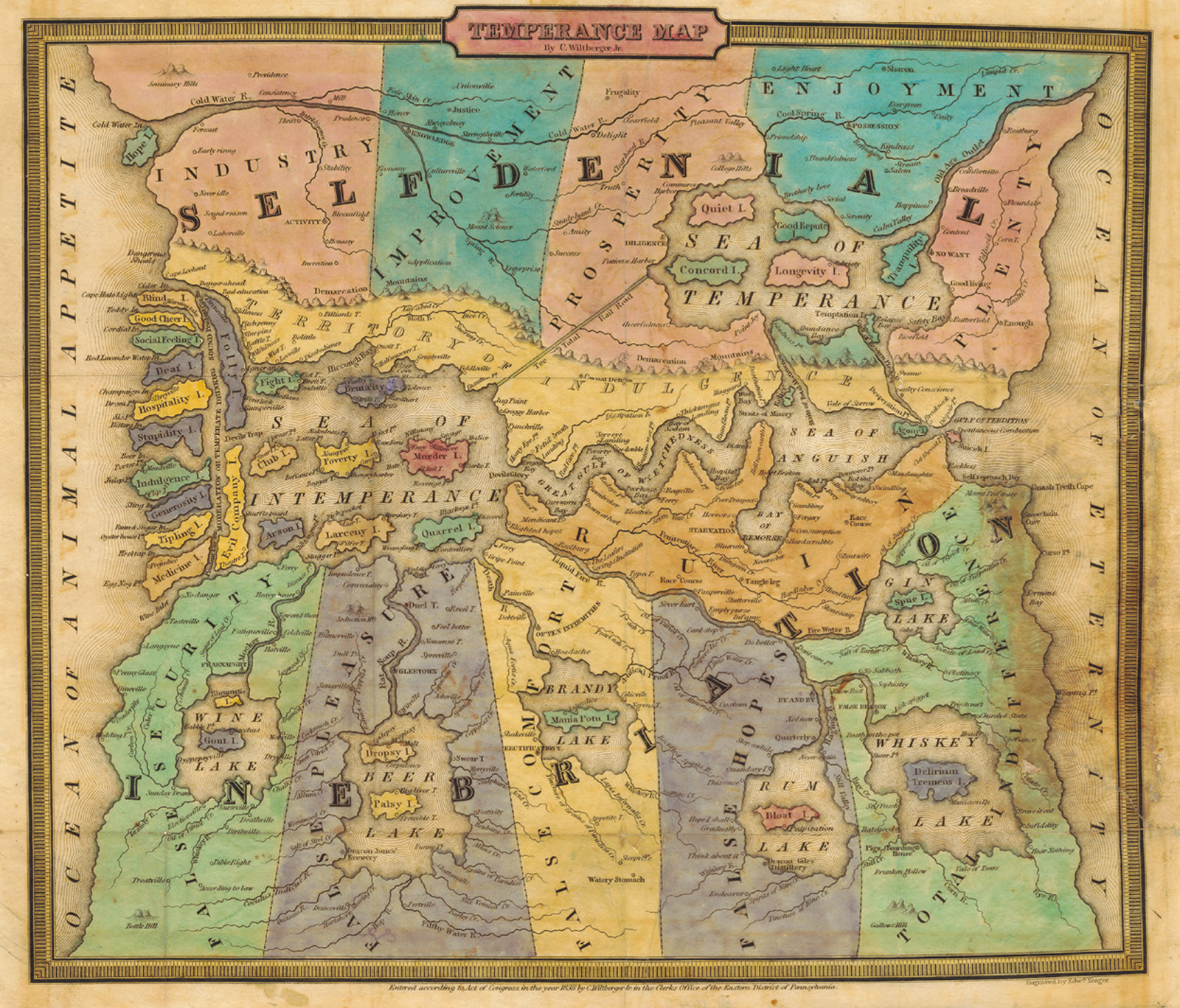
Temperance Map
The Cornell University Library in the U.S. has a Persuasive Cartography Collection with over 1,200 "allegorical, satirical and pictorial" maps which all contain some sort of message.
In this collection, Temperance Map was drawn by Reverend WILTBERGER, a temperance activist, to guide people to abstain from drinking alcohol. On the lower part of the map is the land of Inebriation and on the upper part is the land of Self-Denial (of Desire), while the Sea of Intemperance on the left, which separates the two, is dotted with the islands of Stupidity, Indulgence, Poverty, and Murder. Continuing beyond the Sea of Anguish on the right, the Gulf of Perdition opens its mouth. On the other hand, to the right of the land of Plenty, the islands floating in the Sea of Temperance are given names such as Tranquility, Good Repute and Longevity, evoking images of a world of abundance gained through sobriety.
Etymology of the word "map"
The English word map and the Spanish word mapa are derived from the Latin term mappa mundi. Mappa mundi refers to a medieval Christian map of the world, with mappa meaning "cloth" or "fabric" and mundi meaning "world." It places the holy city of Jerusalem at its center and depicts representations of myths such as Paradise and the Tower of Babel.
The German word karte, the French word carte, the Portuguese word cartas, and the Russian word karta are all derived from the Latin word charta meaning "papyrus." On top of being the origin of the word "map," the word charta is also the origin of the word "chart" in the sense of "nautical chart." The words map and karte do not stem from the concept of a map but instead both derive from the material on which maps are drawn.
In Japanese, the word chizu (地図) originates from China, with the character for chi (地) meaning "universe," "earth," or "land," and the character for zu (図) meaning "the area where grain is cultivated." In China, the word was already in use in the 4th century BC, a period in which many maps seemed to have been made.
World variations in map symbols
Symbols used in maps are created based on the shape of an object being conveyed or related character and are meant to be simple and easily associated with it. However, just as there are many languages in the world, map symbols also vary according to the language and cultural background of each country.

For example, the meanings of the map symbols are, from the top row left to right: hotel (Austria) and school (USA); and from the bottom row left to right: Self Defense Forces (Japan), castle (Germany), and city hall (Netherlands). Even though they all have a similar flag motif, they all represent different concepts.
In countries that use alphabets, it is said that the use of symbols is less common as many word abbreviations are used. In Japan, however, due in part to the complexity of land use, there are more types of map symbols than in Western countries, and many of them are difficult to understand for people coming from outside of Japan. For this reason, in 2016, the Geospatial Information Authority of Japan (GSI) published a set of map symbols designed for overseas visitors. For example, the symbol 〶 , which represents a post office in Japan, is derived from the Japanese character "テ" for the sound "te" in Teishin-sho, the Ministry of Communications which controlled the postal service in the Meiji era. For overseas visitors, the post office symbol was thus made into an envelope mark, as similarly used in Western countries.
Has the area of Japan decreased in size?

Since 1882, the GSI has been annually monitoring and publishing the areas of each prefecture, city, ward, town, and village in Japan. Excluding changes caused by crustal movements, tsunami-induced erosion, and similar phenomena, the area of Japan had been continually increasing mainly due to land reclamation, but in 2015, it decreased by 1.53 square kilometers.
Of course, this does not mean that the land area actually shrunk in that year. The reason for this is that in 2014 the map used as a measurement base was switched from the GSI Topographic map of 1:25,000, which had been used until then, to the Digital Japan Basic Map.
With the Digital Japan Basic Map having a large scale of 1:2,500, the coastlines and reefs that had been drawn roughly until then were now drawn in detail, and detailed coastlines that had not been previously drawn on the map were now represented, resulting in a smaller calculated area overall. Furthermore, since a larger scale allows for a more precise representation of coastline irregularities, even the current developments in land surveying technology do not make it possible to represent the accurate length of coastlines.
Here be dragons
In the Middle Ages and early modern times, European cartographers used to draw dragons and sea beasts in the blank spaces of their maps with the intention of telling people to stay away from unexplored areas because of the presence of monsters. For explorers, "Here be dragons" used to also be a phrase symbolizing areas that they aspired for.

The strait that was discovered through an inaccurate map
Portuguese explorer Ferdinand MAGELLAN discovered a map in the archives of the King of Portugal that showed a strait going from the Atlantic Ocean to the Pacific Ocean in the southern South American continent. Keeping this information secret, he led the Spanish fleet with the goal of discovering the Westward Route, setting sail in August 1519 for a round-the-world trip. In January 1520, he arrived at the location where he expected to find the entrance to the strait, but it was in fact the mouth of the La Plata River.
MAGELLAN, however, did not give up at this point and, after regaining his bearings, began to head south. Finally, in October of the same year, he reached the strait separating the southern tip of the South American continent and the island of Isla Grande de Tierra del Fuego. The narrow channel was 560 kilometers long, with a width of 2 to 3 kilometers on the west side. The group passed through the strait in November and then sailed through the Pacific Ocean. In 1521, MAGELLAN was killed during a battle with islanders in the Philippine Islands, but the remaining fleet returned home in 1522, completing the first circumnavigation of the world in history.
What started with an inaccurate map eventually led to the accomplishment of the feat of the century.

The first map of Japan to appear in an atlas
The first edition of Theater of the world (Theatrum Orbis Terrarum) (1579), the world's first atlas produced by Abraham ORTELIUS of the Netherlands, included maps of various countries drawn by 89 cartographers, but none of Japan.
More than a decade later, a map of Japan was included in an extended edition. It is thought that the map was drawn using a draft by the Portuguese Jesuit cartographer Luís TEIXEIRA as a model, with reference to reports by Jesuit missionaries and a type of Japanese maps called Gyoki-zu. This map is considered to be the first modern map of Japan in Europe and remained the standard for maps of Japan in Europe until the mid-17th century.

VERMEER and maps

The Netherlands developed rapidly through maritime trade and entered its Golden Age in the 17th century. Many cartographers emerged, the country became a center for map publishing, and maps and globes also became popular as decorative objects.
Meanwhile, in the world of painting, genre painting emerged, a style of painting which depicts the lives of ordinary citizens. VERMEER, a Dutch painter of this period, painted real wall maps in the background of six of his more than 30 surviving works, and also drew terrestrial and celestial globes in some of his other works.
As an art dealer, VERMEER was familiar with maps as commercial products and it is also said that the world map was a symbol of longing for him, who spent his entire life in the Netherlands.
The elaborate maps drawn by VERMEER are a valuable source of information on original old maps that were lost.
- Current page: page 1
- page 2
- 1 / 2
- Next page
- The last page
The issue this article appears
No.64 "Map"
Maps invite people into the unknown, and people get thrilled when presented with one―a simple sheet of paper.
From maps carved into rocks and historically ancient maps used in old times, to digital maps made by satellite in the modern era, we humans have been perceiving the world through a variety of maps.Not only do they help us visualize the world’s shape and overall appearance, but sometimes imaginary worlds are also constructed based on them.
In this issue showcasing various maps, we examine how people have been trying to view the world and what they are trying to see.In the Obayashi Project, we took on the challenge of deciphering and reconstructing in three dimensions a fictional city map called the Hashihara Castle Town Map (Hashiharashi Joka Ezu) drawn by Kokugaku scholar MOTOORI Norinaga when he was nineteen years old.
(Published in 2025)
-
Gravure: Is this also a map?
- View Detail
-
What Is a Map?
MORITA Takashi
(Professor Emeritus, Hosei University) - View Detail
-
The Frontiers of Maps: From the Present to the Future
WAKABAYASHI Yoshiki
(Professor Emeritus, Tokyo Metropolitan University) - View Detail
-
Visible World, Invisible World
OTA Akio
(Professor, Department of Visual Communication Design, College of Art and Design, Musashino Art University) - View Detail
-
The Dreams and Solitude of a Youth Who Drew Maps
YOSHIDA Yoshiyuki
(Honorary Director, Museum of Motoori Norinaga) - View Detail
-
OBAYASHI PROJECT
Deciphering the Hashihara Castle Town Map: The Imaginary Town of MOTOORI Norinaga
Speculative Reconstruction by Obayashi Project Team
- View Detail
-
FUJIMORI Terunobu’s “Origins of Architecture” Series No. 15: Japanese Datum of Leveling Monument
FUJIMORI Terunobu
(Architectural historian and architect; Director, Tokyo Metropolitan Edo-Tokyo Museum; and Emeritus Professor, University of Tokyo) - View Detail
-
Interesting Facts About Maps
- View Detail