The Frontiers of Maps: From the Present to the Future
WAKABAYASHI Yoshiki
(Professor Emeritus, Tokyo Metropolitan University)
How digitalization has transformed maps
The rapid progress of the digitalization of information since the end of the 20th century has permeated various domains of society and dramatically transformed our lives. Maps are no exception, and their modes of representation, forms, and uses have changed under the powerful influence of digitalization. The technological foundation supporting such changes includes the growing use of computers, the development of the Internet, as well as the acquisition of location information through satellite positioning system and a variety of sensors.
To summarize the changes to maps brought about by digitalization in a nutshell, it can be said that there is now a separation between a map's representation form and its information content. In other words, maps during the analog era had an inseparable relationship between the mode of representation and information for each material, but with digitalization, information can now be stored almost indefinitely in computer memory and represented in various forms on maps. Geographic information systems (GIS) that exist today can process the isolated geospatial information and, on the basis of the same information, select not only maps but also a wide variety of different modes of representation. In addition, the use of the Internet as a medium for maps has also expanded the range of map makers and users, thereby promoting the sharing of information.
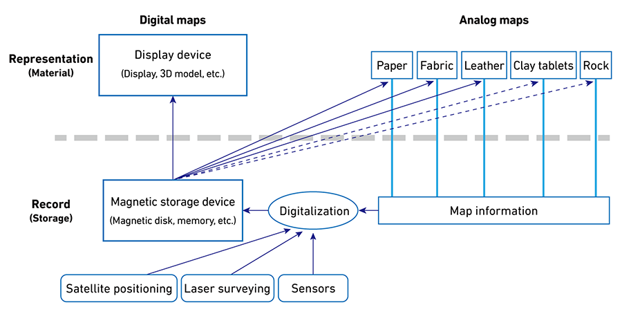
The figure shows the forms of representation of maps on the top, the information content of maps on the bottom, with the dotted and dashed arrows indicating the flow of information (with dashed arrows indicating weak connections).
This paper will discuss these changes in greater detail by dividing them into the methods of collecting and creating geospatial information, cartographic representations, and the uses of maps, before examining what will remain unchanged even with digitalization and considering future issues.
Changes in the methods of collecting geospatial information and making maps
The first step in creating a map is to determine a location on the earth. In the past, location information was obtained by surveying on the ground based on reference points, but the advent of Global Navigation Satellite Systems (GNSS) (*1) has dramatically changed this. This change was sparked by the discontinuation in 2000 of the intentional accuracy degradation (*2) of the Global Positioning System (GPS), which was initially launched by the United States for military use, in order to promote civilian use of the system and allow users to promptly obtain location information for any point. This made it possible to determine the latitude and longitude of one's current location in real time using a GPS receiver on the ground, a technology currently used in car and smartphone navigation systems.
*1 A general term that refers to satellite-based positioning systems. Such systems include the GPS (United States), GLONASS (Russia), and Galileo (EU). *2 Positioning accuracy had been degraded through Selective Availability (SA) in an attempt to maintain U.S. military supremacy.
On the other hand, satellite positioning data previously had the disadvantage that its accuracy was affected by radio wave conditions, limiting its use to open-sky environments. To rectify this problem, technologies have been developed to promptly and accurately obtain location information by adding correction information on the ground. Examples include the use of accelerometer and electronic compasses built into smartphones, as well as the correction of location information using radio waves from base stations of telephone companies. Location information obtained through smartphones is stored by phone companies and reused in a manner that does not allow specific individuals to be identified. During the COVID-19 pandemic, location information obtained through smartphones was used to generate human flow data, which was in turn used to capture the movement of people at different times of the day to prevent COVID-19 transmission.
Surveying technology such as laser surveying has also made it possible to acquire data with dramatically higher accuracy. Three-dimensional point cloud data obtained from laser surveying, which can be used not only in the air but also on the ground, has paved the way for the utilization of three-dimensional geospatial information.
Various types of geospatial information have been collected and accumulated in this manner, and the methods of obtaining such information have become increasingly diverse. Certain kinds of data, including location information, which used to be expensive and difficult to obtain, can now be retrieved as open data from government agencies. In addition to e-Stat (the portal site for Japanese Government statistics) and digital land information provided by the government, a variety of open data is now available on the websites of local governments. This trend was largely the result of the Basic Act on the Advancement of Utilizing Geospatial Information enacted in 2007 and open data initiatives around the world. According to one survey, geospatial information accounts for 80% of all information on the Internet, and while not all information has been converted into maps, maps are clearly the most effective means of representing such information. The abundant data that has been accumulated in this manner includes big data which exceeds terabytes in size and whose handling requires GIS and data science skills.
Meanwhile, the burgeoning Internet has enabled the number of mapmakers to grow, with greater community participation in mapmaking. Exemplary of this is the OpenStreetMap (OSM) initiative that began in the United Kingdom in 2004. Volunteer mapmakers (mappers) participate in the creation of map data by uploading GPS movement records and tracing satellite images, and the resulting maps are edited and published for free. An OSM local chapter was established in Japan in 2008, and by 2020, the number of registered users had reached 6 million worldwide.

Screen for the editing process in OSM, where roads and other geographical features are traced from the underlying satellite images
https://osmfoundation.org
This framework of having the general public contribute to data creation can be thought of as a crowdsourcing activity similar to how Wikipedia operates. Crowdsourcing geospatial information involves not only volunteers as in OSM but also users who have given prior consent for their location information to be collected. For example, traffic congestion information in Google Maps uses location information provided by smartphone users.
While OSM creates the base map information, Flightradar24 and MarineTraffic are examples of platforms whose volunteers are responsible for the subject information published on such maps. Flightradar24 displays the real-time flight information of commercial aircraft around the world on a map through the use of data collected by volunteers around the world who receive radio signals from traffic collision avoidance systems of aircraft that have been made publicly available and forward them to a server. Likewise, MarineTraffic is a map showing the real-time location of ships around the world using data collected by volunteers from the Automatic Identification System (AIS) for ships that is aggregated on a server and made publicly available.

Given the limits of human power in mapping such a massive amount of data, artificial intelligence (AI) is also being increasingly utilized. For example, the use of image recognition based on machine learning can facilitate the automatic identification of geographical features from aerial photographs and satellite images and allow maps to be automatically created. This would allow much of the work involved in map creation to be taken over by AI going forward. On the other hand, deepfake maps can also be created by generative AI, and such fictitious maps may spark confusion in society depending on how they are used.
- Current page: page 1
- page 2
- 1 / 2
- Next page
- The last page
WAKABAYASHI Yoshiki
(Professor Emeritus, Tokyo Metropolitan University)
Born in 1959. Graduated from Doctoral Course of Graduate School of Letters, Hiroshima University. PhD. His specialty is geography, cartography and geographic information science. His main publications are How to Read and Make Maps in a Digital Society (Dejitaru shakai no chizu no yomikata tsukurikata), Evolution of Maps (Chizu no shinkaron: chirikukanjoho to ningen no mirai), Theory and Applications of Participatory GIS (Sankagata GIS no riron to oyo), and Ubiquitous Mapping.
The issue this article appears
No.64 "Map"
Maps invite people into the unknown, and people get thrilled when presented with one―a simple sheet of paper.
From maps carved into rocks and historically ancient maps used in old times, to digital maps made by satellite in the modern era, we humans have been perceiving the world through a variety of maps.Not only do they help us visualize the world’s shape and overall appearance, but sometimes imaginary worlds are also constructed based on them.
In this issue showcasing various maps, we examine how people have been trying to view the world and what they are trying to see.In the Obayashi Project, we took on the challenge of deciphering and reconstructing in three dimensions a fictional city map called the Hashihara Castle Town Map (Hashiharashi Joka Ezu) drawn by Kokugaku scholar MOTOORI Norinaga when he was nineteen years old.
(Published in 2025)
-
Gravure: Is this also a map?
- View Detail
-
What Is a Map?
MORITA Takashi
(Professor Emeritus, Hosei University) - View Detail
-
The Frontiers of Maps: From the Present to the Future
WAKABAYASHI Yoshiki
(Professor Emeritus, Tokyo Metropolitan University) - View Detail
-
Visible World, Invisible World
OTA Akio
(Professor, Department of Visual Communication Design, College of Art and Design, Musashino Art University) - View Detail
-
The Dreams and Solitude of a Youth Who Drew Maps
YOSHIDA Yoshiyuki
(Honorary Director, Museum of Motoori Norinaga) - View Detail
-
OBAYASHI PROJECT
Deciphering the Hashihara Castle Town Map: The Imaginary Town of MOTOORI Norinaga
Speculative Reconstruction by Obayashi Project Team
- View Detail
-
FUJIMORI Terunobu’s “Origins of Architecture” Series No. 15: Japanese Datum of Leveling Monument
FUJIMORI Terunobu
(Architectural historian and architect; Director, Tokyo Metropolitan Edo-Tokyo Museum; and Emeritus Professor, University of Tokyo) - View Detail
-
Interesting Facts About Maps
- View Detail