Deciphering the Hashihara Castle Town Map: The Imaginary Town of MOTOORI Norinaga
Speculative Reconstruction by Obayashi Project Team

MOTOORI Norinaga was an Edo-period intellectual giant known for his meticulous study of the classics. The Hashihara Castle Town Map (Hashiharashi Joka Ezu) is a map of a fictitious ideal town that he drew along with the Genealogical Table of the HASHIHARA Family (Hashiharashi Keizu) at the age of nineteen. The map depicts the entirety of a castle town surrounded by natural terrain, and it contains the names of people in the genealogical table. The map also shows many shrines and temples in the surrounding mountains, with rivers and bridges having names derived from the classics, suggesting a culturally vibrant town. What was the significance of this map for Norinaga? This project closely examines the Hashihara Castle Town Map and visualizes the process of deciphering the map. Its goal is to create a three-dimensional reconstruction of the town envisioned by the young Norinaga and give physical form to his ideas.
Prologue: Discovery of the mysterious map and genealogical table
Born in 1730 in Matsusaka, Ise Province, MOTOORI Norinaga later became one of Japan's leading Kokugaku scholars. The main subject of this project is an old map he drew at the age of nineteen, when he was still going by the name OZU Yoshisada.
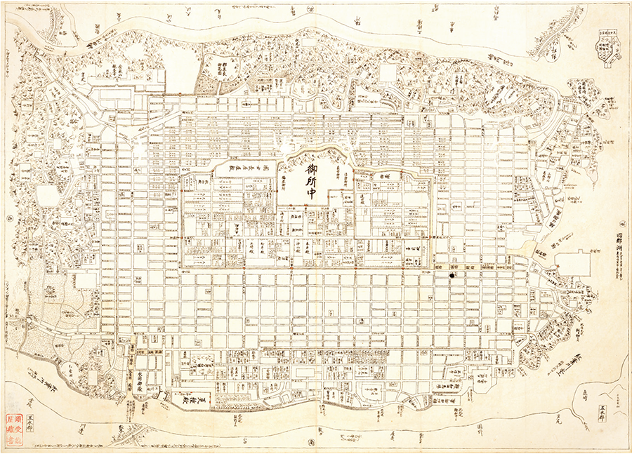
This map known as the Hashihara Castle Town Map has long been part of the collection at the Museum of Motoori Norinaga in Matsusaka City, but its origins are shrouded in mystery. While some people had pointed out its resemblance to the townscape of Kyoto, the town on the map is inconsistent with any known town or city, and no one had been able to find a definite answer to the question of what Norinaga intended to draw.
However, the key to solving this mystery emerged in an unexpected way. In 1978, an ancient document was discovered during a survey of the museum's collection by the Agency for Cultural Affairs. It was the Genealogical Table of the HASHIHARA Family that Norinaga had written on the back of a draft of a waka poem anthology entitled Kokinsen. The genealogical table contains Okeizu, which traces the HASHIHARA family from its ancestors to its 15th head, Nobumasa; Gokeizu, which traces the direct lineage from Nobumasa; as well as extensive genealogical records of more than two hundred vassals, classified in order of rank: Gobunke, Gohokyaku, On'ozamurai, Osamuraikoke, and Osamurai.
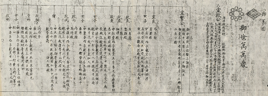
At the beginning of Okeizu is the name of a non-existent divinity, "Omichisaki no Honushi." In addition, the years and names of places in the genealogical table were all created by Norinaga. However, the table contains a staggering volume of information and level of detail.
High-ranking samurai are described in detail from their origins to their chigyo-chi (territory) (*1), kokudaka (yield), the location of their mansions and suburban residences, year of birth/death, childhood names, official positions, and even their mothers, wives, and vassals. Details for lower-ranking samurai are simplified according to their rank but still include their kokudaka, the location of their residences, year of birth, and official positions.
*1 Land granted by daimyo (feudal lords) to their vassals
OKAMOTO Masaru, a scholar of Japanese literature who was present at the discovery of the Genealogical Table of the HASHIHARA Family, noticed a surprising fact. After carefully examining the names of people and places listed in the genealogical table, he found that they were almost exactly the same as those depicted in the Hashihara Castle Town Map. For example, the locations of samurai mansions and suburban residences listed in the genealogical table correspond exactly to the layout of buildings on the map. This discovery suggested that the Hashihara Castle Town Map is a counterpart to the Genealogical Table of the HASHIHARA Family and can be deemed a so-called blueprint of the castle town ruled by the HASHIHARA family that Norinaga envisioned.
Since there are no traces of raw sketches in the map, it is believed that the nineteen-year-old Norinaga first conceived of the extensive genealogical table before drawing the detailed map on the basis of the elaborate table.
When he subsequently started his career as a scholar, Norinaga repurposed the reverse side of the genealogical table for writing the draft of Kokinsen in order to make effective use of Japanese washi paper, which was a precious commodity at the time. The vestiges of the young Norinaga's creative endeavors therefore lay hidden, unnoticed by others until many generations later.
This discovery raises a new question for us today. Why did Norinaga create such an elaborate fictitious world?
OBAYASHI CORPORATION set up an in-house project team to tackle this mystery. The team analyzed the layout of buildings and the configuration of roads depicted in the Hashihara Castle Town Map from a historical perspective and studied various information, such as the natural landscape surrounding the town center and cultural facilities marked in various locations, in its attempt to decipher the town that Norinaga had drawn in this fictitious map. Furthermore, by reproducing the worldview represented in this map in the form of 3D images, the team aimed to visualize the imaginary town envisioned by Norinaga.
The significance of this project goes beyond merely analyzing and producing 3D renderings of an ancient map.
It is an ambitious attempt to give form to a town drawn by a perceptive nineteen-year-old genius and the ideas that went into its conception over 250 years ago.
In what form will the town drawn by Norinaga be revived in the present age?
The process of deciphering the map
A project to reconstruct the Hashihara Castle Town Map was launched in the spring of 2024. A project team consisting of experts in architecture, landscaping, and urban development, as well as employees with expertise in traditional architecture and history, came together and set out to decipher Norinaga's fictitious world.
The project team first studied the map and the genealogical table, and methodically identified what appear to be their features from various angles. It then conducted a comparative review involving other castle towns and literature from the period to validate the features of the Hashihara castle town depicted on the map.
Furthermore, the team extracted points of note under themes such as defense, disaster prevention, logistics (land/water transport), waterways (clean water and wastewater), streets, urban infrastructure, nature, and festivals, before analyzing and reviewing these points.
In the process, the team studied on site the topography, nature, and architecture of Matsusaka and Kyoto, and received advice from YOSHIDA Yoshiyuki, Director Emeritus of the Museum of Motoori Norinaga, and Professor UESUGI Kazuhiro of Kyoto Prefectural University, who specializes in historical geography and cultural landscape studies, to improve the accuracy of the analysis.
Through a combination of approaches from specialized fields and historical research, the landscape of the town envisioned by Norinaga gradually began to reveal itself. The Hashihara Castle Town Map is therefore not merely an imaginary map but the blueprint of an ideal town that embodies the principles of an individual who would later become a leading intellectual of the Edo period.
The issue this article appears
No.64 "Map"
Maps invite people into the unknown, and people get thrilled when presented with one―a simple sheet of paper.
From maps carved into rocks and historically ancient maps used in old times, to digital maps made by satellite in the modern era, we humans have been perceiving the world through a variety of maps.Not only do they help us visualize the world’s shape and overall appearance, but sometimes imaginary worlds are also constructed based on them.
In this issue showcasing various maps, we examine how people have been trying to view the world and what they are trying to see.In the Obayashi Project, we took on the challenge of deciphering and reconstructing in three dimensions a fictional city map called the Hashihara Castle Town Map (Hashiharashi Joka Ezu) drawn by Kokugaku scholar MOTOORI Norinaga when he was nineteen years old.
(Published in 2025)
-
Gravure: Is this also a map?
- View Detail
-
What Is a Map?
MORITA Takashi
(Professor Emeritus, Hosei University) - View Detail
-
The Frontiers of Maps: From the Present to the Future
WAKABAYASHI Yoshiki
(Professor Emeritus, Tokyo Metropolitan University) - View Detail
-
Visible World, Invisible World
OTA Akio
(Professor, Department of Visual Communication Design, College of Art and Design, Musashino Art University) - View Detail
-
The Dreams and Solitude of a Youth Who Drew Maps
YOSHIDA Yoshiyuki
(Honorary Director, Museum of Motoori Norinaga) - View Detail
-
OBAYASHI PROJECT
Deciphering the Hashihara Castle Town Map: The Imaginary Town of MOTOORI Norinaga
Speculative Reconstruction by Obayashi Project Team
- View Detail
-
FUJIMORI Terunobu’s “Origins of Architecture” Series No. 15: Japanese Datum of Leveling Monument
FUJIMORI Terunobu
(Architectural historian and architect; Director, Tokyo Metropolitan Edo-Tokyo Museum; and Emeritus Professor, University of Tokyo) - View Detail
-
Interesting Facts About Maps
- View Detail