Deciphering the Hashihara Castle Town Map: The Imaginary Town of MOTOORI Norinaga
Speculative Reconstruction by Obayashi Project Team

Let us take a closer look at the facts revealed by the project team's work in deciphering the map and the process of arriving at its conjectures based on them.
1. A new town in the Edo period
According to the Genealogical Table of the HASHIHARA Family the lord of the imperial palace depicted in the center of the Hashihara Castle Town Map was Nobumasa, the 15th head of the HASHIHARA family. What was the town ruled by the castle lord Nobumasa like? And what was that period like?
According to the genealogical table, members of the HASHIHARA family were originally vassals of a family called KATSUYAMA. Three years before the establishment of the Hashihara castle town, in the first year of the Michifusa era, Masahiro, the fifth son of Nobumasa, died in battle. Records showed that two others also died in battle and one was executed. It was then explained from the perspective of Nobumasa that a "nationwide cleanup" took place, leading to "peace and tranquility" in the third year of the Michifusa era. In other words, it can be interpreted that even though there was war three years ago, Nobumasa brought an end to the war one year ago and was ruling the country and the castle town in peace in the place of the KATSUYAMA family.
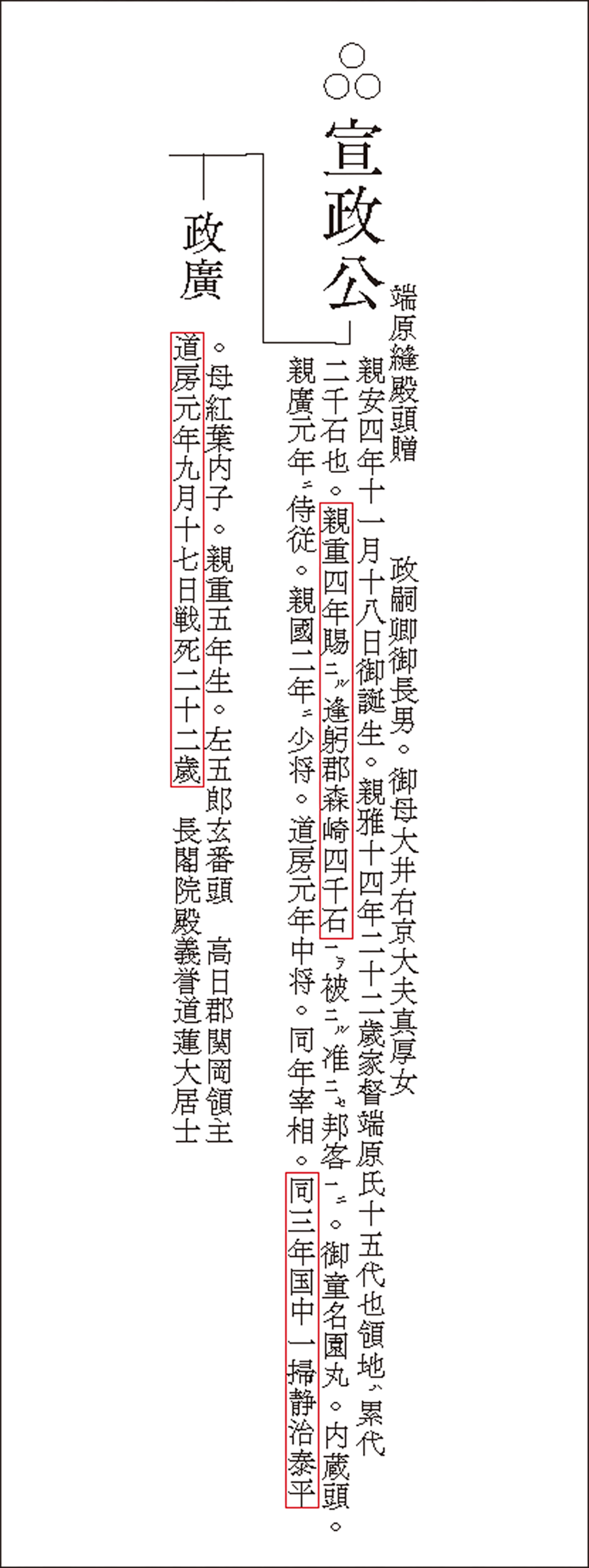
The HASHIHARA family had originally ruled a different territory, but it ended the war and established the new Hashihara castle town. Given the ensuing stability and peace in the world, Nobumasa may have attempted to create a new ideal town in this area.
In addition, it can be seen from the genealogical table that (1) two daughters of townspeople were concubines of HASHIHARA Nobumasa, which suggests that this was unlikely to have been a period with a pervasive class system; and that (2) the family name HASHIHARA was first adopted by an ancestor 14 generations before Nobumasa by taking the name of his territory, which indicates that a considerable period of time had passed since the Kamakura period, when the practice of using place names as family names began. Furthermore, the map shows that the moat and parts of the river were fortified by stone walls, a technique used from the Edo period onward.
Based on these observations, the project team assumed the map's historical background to be the mid-Edo period when MOTOORI Norinaga lived.
[Brief chronological record of HASHIHARA Nobumasa (made from the Genealogical Table of the HASHIHARA Family (Hashiharashi Keizu))]
| Shin'an 4 | Birth of Nobumasa | |
| Shin'an 10 | Birth of Kita no Okata (Nobumasa's wife) | |
| Shinga 13 | Marriage to Kita no Okata | |
| Shinga 14 | Succeeds to the family headship | |
| Shinga 15 | Birth of his eldest son Nobushige; death of his mother | |
| Shinju 4 | Is granted territory in Morisaki and treated as equivalent to a Gohokyaku |
|
| Shinko 1 | A battle breaks out, and the On'ozamurai KYUDA Yoshinaga dies in battle Nobumasa is promoted to Jiju (chamberlain) |
|
| Shinkoku 2 | Promoted to Shosho (major general) | |
| Doubou 1 | A battle breaks out, Nobumasa's son HASHIHARA Masahiro, On'ozamurai ASAYAMA Tokuso, On'ozamurai FUJIKURA Tadamitsu, and a member of the Gohokyaku family OI Masashige dies in battle, and a member of the Gohokyaku family WASAKI Korekane is executed Nobumasa is promoted to Chujo (lieutenant general) and then to Saisho (chancellor) |
|
| Doubou 2 | Death of Kita no Okata | |
| Doubou 3 | Nationwide cleanup leading to peace and tranquility | |
| Shou 1 | Becomes the castle lord in place of former ruler Nagamori-dono |
2. The planned town
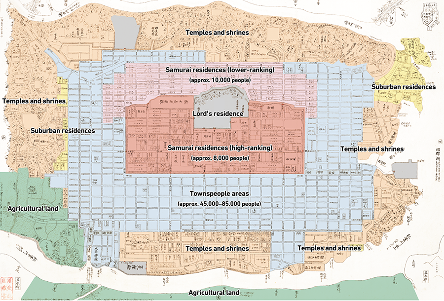
Planned zoning of the town center
At first glance, one will notice that the entire town center was clearly divided by function, including samurai residences, townspeople areas, temples and shrines, and agricultural land on the outskirts, with the imperial palace where the castle lord resided at its heart.
Based on the content of the Genealogical Table of the HASHIHARA Family, residences of high-ranking samurai such as "Gobunke," "Gohokyaku," and "On'ozamurai" were located south of the imperial palace within the moat and walls surrounding the citadel area, while the residences of lower-ranking samurai were densely concentrated on its north side. The townspeople areas were located on the south side and around the imperial palace, while temples and shrines were spread out along the periphery of the town.
The actual castle town was also divided into samurai residences, townspeople areas, temples and shrines, etc., but due to constraints related to topology and existing land use, the division was not as clear-cut as it could be.
From these observations, it can be inferred that the Hashihara castle town had been meticulously planned and developed.
[Zoning and population size estimation]
Residential areas were set out in a strict grid layout
The Hashihara castle town was carved up using a grid layout featuring streets that stretched from north to south and from east to west, with each street given a name. Incidentally, the streets in many castle towns of the same period were not arranged in a strict grid layout. For example, the streets of Matsusaka, the hometown of Norinaga, were not set out in a grid layout, and he later indicated in his essay Tamakatsuma that "the town's streets do not look right." Also, although Kyoto, the city that Norinaga was drawn to and appeared to have used as a reference for his own town layout, features a grid layout, it also has diagonal and curved streets, and, unlike Hashihara castle town, no town in reality is actually composed of entirely straight streets.
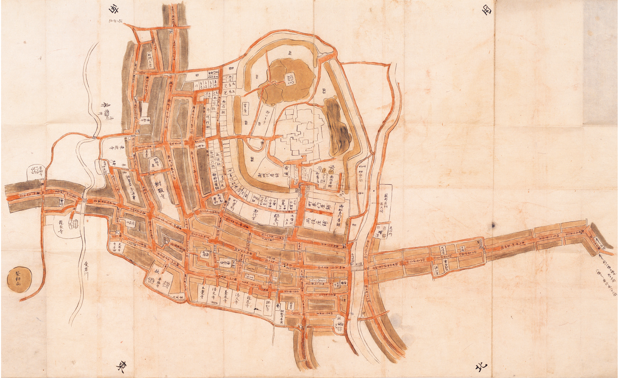
Furthermore, maps of Kyoto at the time sometimes used different vertical and horizontal scales, depicted square districts with rectangles, and even omitted the names of streets. However, the Hashihara Castle Town Map uses the same scale in both vertical and horizontal directions and was marked with the name of every street, making it even more precise in depicting the town than maps of Kyoto at the time.
When the project team identified all the street names and compared them with those in Matsusaka and Kyoto, it was found that although several streets shared the same name with streets in Kyoto, such as Ogi-cho and Kamiya-cho, none corresponded to actual streets in Matsusaka. It seems that Norinaga had avoided the names of real towns and cities and planned a town of his own despite his strong attraction to Kyoto.

Estimation of the size and resident population of the Hashihara castle town
The project team performed an estimation of the town center's size and the resident population of the Hashihara castle town. The first step was to elucidate the scale of the Hashihara Castle Town Map. Only the following three distances were marked on the map:
- ① Distance from Sugino to the Tamatarejima boat crossing
- ② Distance from the boat crossing on the east side of Shin-sonozaki Hachimangu Shrine to the Tamatarejima boat crossing
- ③ Length of Kasenbashi
The distances ① and ② were deemed to be not drawn to scale because there were many instances in maps of that period of distances in peripheral areas becoming less accurate the further away they are from the town or city center. Therefore, the scale of the Hashihara Castle Town Map was determined to be approximately 1/6,200 based on the actual measurements for ③. On the basis of this scale, the area of the town center was calculated to be approximately 6 km2, or around 3 km from east to west and around 2 km from north to south, which is about half the size of the current Chiyoda Ward in Tokyo.
[Scale examination and Layout of townhouses]
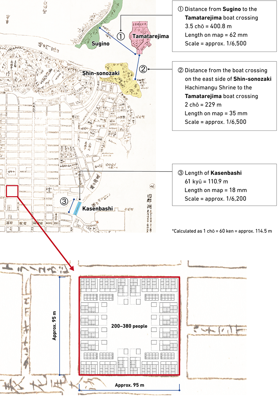
By defining each square block often seen in the townspeople area to the south of the (high-ranking) samurai residences as one district, the size of the townspeople area was calculated to be approximately 9,000 m2 (around 95 × 95 m) per block, or around 50 ken when converted to the unit of length used during that period. The scale suggested that the districts had been planned to be more compact than those in Edo and Kyoto, whose layout was based on around 60 ken per block at the time. Nagoya, however, had districts with around 50 ken per block.
The townspeople areas were annotated with only the names of streets and nothing else. It was common practice to avoid annotating townspeople areas in great detail on maps of that period.
In the Edo period, districts in townspeople areas had vacant lots known as centrally owned land, where town houses were built along streets. Some districts had a road running through the center, while others had temples and shrines built on them. This is because roads, temples, and shrines were often planned on vacant lots. At the same time, it is thought that the construction of new public facilities was avoided in vacant lots within districts where influential townspeople lived.
The population was calculated by applying the average number of residents at the time to each district based on the size of buildings in general during the Edo period. Therefore, assuming that 200 to 380 people lived in each district of the townspeople areas, these figures were applied to the 220-odd districts of the townspeople areas to arrive at an estimated total resident population of 45,000 to 85,000 townspeople.
The same method was used to calculate the resident population of samurai residences. Within the citadel area comprising high-ranking samurai residences, the population was estimated to be around 8,000 people based on the kokudaka figures indicated in the family structure materials and genealogical tables for the HIKONE clan during the Edo period. For the area allocated to lower-ranking samurai, the resident population was calculated to be around 10,000 people based on the number of households in the residences listed in each plot and the assumption that four individuals lived in each household.
Based on the above, the total population of the town center of the Hashihara castle town was estimated to be in the range of 60,000 to 100,000. The project team also arrived at a population estimate of around 88,000 people by calculating the population density of the castle town based on the population of Kyoto's Rakuchu area in 1730 and applying it to the area of the map. Given the proximity of these two values derived from two different approaches, the project team concluded that this population estimate was reasonable.
In the process of estimating the population, the project team placed town houses and samurai residences of standard sizes built during that period in each district according to the scale and found that most of these buildings fit perfectly within the plots.
This suggests that Norinaga had meticulously planned the width of streets, districts, and the population, and he even accurately determined the sizes of samurai residences and ordinary houses at the time in order to plan the residential plots with precision. This map can thus be said to be an accurate representation of Norinaga's town plan.
A closer look at the ruler Nobumasa and the location of the castle town
What was the rank of the daimyo Nobumasa, the ruler of the castle town? The total kokudaka of his vassals listed in the genealogical table was 280,000 koku, and his territory was spread over 22 gun (districts). Based on this information, it can be estimated that Nobumasa's kokudaka was in the range of around 500,000 to 900,000 koku, which is equivalent to that of a daimyo of the WAKAYAMA clan that ruled Matsusaka where Norinaga lived, or the OWARI clan under the same Gosanke (three noble houses) as the WAKAYAMA clan. In terms of population, Nagoya, the castle town of the OWARI clan, had a population of under 100,000, which was roughly the same or slightly larger than that of Hashihara, estimated to be in the range of 60,000 to 100,000.
As for the location of the Hashihara castle town, it was indicated that the town was located 2.5 ri from the port, or around 10 km from the sea. Based on the direction of flow of the river, it is thought that the sea would be to the left of the map, on the west side.
On the other hand, it is unclear which part of Japan the town was supposed to be located. One clue is that coniferous and broad-leaved forests, as well as plum and cherry trees, were depicted in the mountainous areas. The simultaneous presence of these plants points to many possible regions in Japan, although extremely cold regions in northern Japan as well as southern regions of Japan with few coniferous forests can be ruled out.
In his later years, Norinaga described Ise Province, where Matsusaka is located, as being "neither too cold nor too hot as compared to other provinces," and it is highly likely he had in mind a region with such a warm and pleasant climate.
- The first page
- Previous page
- page 1
- Current page: page 2
- page 3
- page 4
- page 5
- 2 / 5
- Next page
- The last page
The issue this article appears
No.64 "Map"
Maps invite people into the unknown, and people get thrilled when presented with one―a simple sheet of paper.
From maps carved into rocks and historically ancient maps used in old times, to digital maps made by satellite in the modern era, we humans have been perceiving the world through a variety of maps.Not only do they help us visualize the world’s shape and overall appearance, but sometimes imaginary worlds are also constructed based on them.
In this issue showcasing various maps, we examine how people have been trying to view the world and what they are trying to see.In the Obayashi Project, we took on the challenge of deciphering and reconstructing in three dimensions a fictional city map called the Hashihara Castle Town Map (Hashiharashi Joka Ezu) drawn by Kokugaku scholar MOTOORI Norinaga when he was nineteen years old.
(Published in 2025)
-
Gravure: Is this also a map?
- View Detail
-
What Is a Map?
MORITA Takashi
(Professor Emeritus, Hosei University) - View Detail
-
The Frontiers of Maps: From the Present to the Future
WAKABAYASHI Yoshiki
(Professor Emeritus, Tokyo Metropolitan University) - View Detail
-
Visible World, Invisible World
OTA Akio
(Professor, Department of Visual Communication Design, College of Art and Design, Musashino Art University) - View Detail
-
The Dreams and Solitude of a Youth Who Drew Maps
YOSHIDA Yoshiyuki
(Honorary Director, Museum of Motoori Norinaga) - View Detail
-
OBAYASHI PROJECT
Deciphering the Hashihara Castle Town Map: The Imaginary Town of MOTOORI Norinaga
Speculative Reconstruction by Obayashi Project Team
- View Detail
-
FUJIMORI Terunobu’s “Origins of Architecture” Series No. 15: Japanese Datum of Leveling Monument
FUJIMORI Terunobu
(Architectural historian and architect; Director, Tokyo Metropolitan Edo-Tokyo Museum; and Emeritus Professor, University of Tokyo) - View Detail
-
Interesting Facts About Maps
- View Detail