Deciphering the Hashihara Castle Town Map: The Imaginary Town of MOTOORI Norinaga
Speculative Reconstruction by Obayashi Project Team

Thoughts on the project
OBAYASHI Project Team
- YAMASAKI Shinji (Traditional Architecture)
- ARAKAWA Tsukasa (Traditional Architecture)
- INABA Kazuhide (Traditional Architecture)
- IWAI Hiroshi (Landscaping)
- NISHIZAKI Mayumi (Landscaping)
- SUZUKI Koichi (Urban Development)
- OGUNI Keita (Urban Development)
- OSAWA Tomofumi (History/Castles)
- MATSUSHITA Takashi (Illustration/CG, OBAYASHI DESIGN PARTNERS)
Impressions of the map and the joy of deciphering it
YAMASAKI: It is finally time to announce the restoration project that you have been working on for a year. First of all, could you tell us what you felt when you first looked at the map?
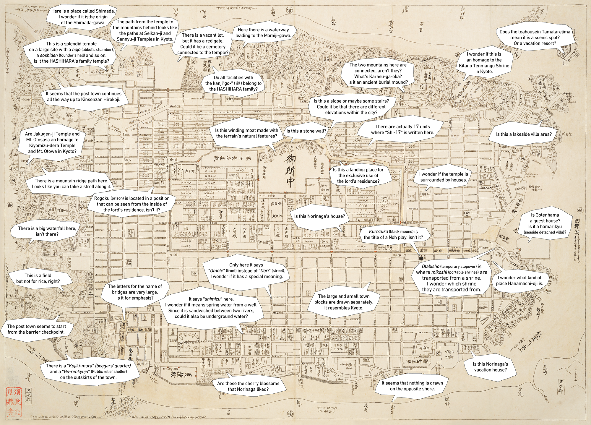
OSAWA: I first saw the castle because it is a castle town map, and I noticed its unusual shape and its many gates. I became curious about what the owner of the castle, HASHIHARA, was like.
SUZUKI: I was curious about the size of the town. So, we first considered the scaling to get a sense of the overall scale during the development process.
OGUNI: I often look at maps as I travel for work, and I was curious about which city this map was modeled after. I got the impression from the town's features, including its well-organized urban layout and the presence of an imperial palace, that it was a town resembling Kyoto.
NISHIZAKI: I was drawn to small details such as the water wells, creating the small stream of spring water, and the river on the west side of the town center flowing from top to bottom, which showed the difference in elevation. It was very interesting to discover these features one by one and imagine not only the town's physical characteristics but also the lifestyle of its residents.
IWAI: In landscaping, we often use old maps as clues to figure out what kind of place the site in question used to be. I was surprised that even though this is a fictitious map, it was more detailed than the old maps we usually see, and that it even showed the surrounding areas.
ARAKAWA: My first impression was that despite it being easier to create a fictitious town by simply drawing straight gridlines, the map was made more realistic by incorporating natural curves.
INABA: We explored the meaning of what was drawn on the map, but since it is fictitious in nature, there was no right interpretation, and there was no way of knowing if we were right or wrong. This allowed us to freely express our opinions, and it was fascinating to listen to the opinions of members with different specialties and let our imagination run wild.
YAMASAKI: This map is tied to a genealogical table, right?
OSAWA: That's right. It is an extensive genealogical table that lists even the vassals. When reading the map, I thought that relatives listed in the genealogical table might be positioned near each other, but that turned out not to be the case. Since the genealogical table was well thought out, I wondered if the map had been created with rules such as not placing relatives near each other.
IWAI: I find this quite similar to how a plot in a novel works, where details of a character's background are set up to give the story more depth. It would have been even more amazing if this map was drawn as the background to a story, such as someone living close to the imperial palace.
OSAWA: There is some debate as to whether the map was drawn with a story in mind, but since the genealogical table and the map were created around the time Norinaga was reading war chronicles and The Tale of Genji (genji monogatari), I believe he was thinking of a story as well.
OGUNI: There is also a possibility in which such things are found written on the back of some piece of paper when you search elsewhere.
NISHIZAKI: The map reminded me of scenes from MURAKAMI Haruki's novel about parallel worlds. If Norinaga depicted a world other than the one in which he lived, I believe he had a story in mind.
OSAWA: He even drew a mandokoro (administrative body in ancient Japan), which should not have existed during the Edo period.
What kind of person was Norinaga?
YAMASAKI: Next, I would like to discuss the "kind of person Norinaga was." I feel that he was strongly drawn to Kyoto, was very curious, and wanted to learn as much as possible.
ARAKAWA: I believe he was like a kid professor. He had a wealth of knowledge and was good at organizing it. Although that was an amazing talent, he was trying to accurately understand the position of the world that he knew from a spatial and temporal perspective. Rather than just gathering knowledge, he narrowed it down to a certain extent and organized it thoroughly.
NISHIZAKI: A meticulous person would draw maps using straight lines only or shapes that made sense, but the periphery of the map is full of freeform lines and achieves balance on the whole, so I believe Norinaga was not only meticulous but also generous.
IWAI: While the castle town is contained within a grid, the topography of the surrounding area is so detailed that it must have been modeled after something. This was no easy feat.
INABA: He was looking at the topography of Kyoto and Matsusaka. It would not have been interesting if the map was just a grid pattern, and what makes it interesting is how everyone sensed what lay behind the map. From an architectural point of view, the plantings were drawn in great detail but the buildings are only drawn as gates and towers. I wonder if he had little interest in architecture.
By the way, does the genealogical table tell us anything?
OSAWA: The "Nori" in Norinaga's name was taken from the same Japanese kanji character (宣) in the name of KIYOHARA no Nobukata, a court noble from the Warring States period. Given that the same character is in the name of the monarch Nobumasa, Norinaga probably already knew about that person.
YAMASAKI: Perhaps there was some admiration involved.
IWAI: Townspeople areas make up a very large percentage of this town. Since this was a time when samurai residences dominated the area, we can feel that Norinaga was indeed the son of a merchant.
Why was the map drawn with such intricate details?
YAMASAKI: What are your thoughts on the mystery of why Norinaga created a fictitious map with such intricate details?
SUZUKI: He had some ideas and an ideal vision of the kind of town he wanted to live in, so he filled it with everything he wanted it to have. For example, he had to be more precise when filling in details such as the population using the number of people living in row houses as a reference.
OGUNI: I believe Norinaga drew this map as a setting for expressing his own worldview. This is not simply a map of a town, but since it also assumes the presence of people, I think he wanted to express his ideal worldview, including the activities and stories the town gave rise to.
There was probably also an element of play involved. Even those specializing in urban planning rarely draw their ideal towns, and even if they did, they would not give much thought to differences in elevation. However, the stairways and slopes in the map were drawn in great detail, and in the Tanimachi-oji area in the upper right of the map, there are some routes that are not straight but deliberately depicted in a ridge trail-like manner that shows their elevation.
INABA: I think Norinaga was very anxious and worried about the times he was living in and the future. Thus, he envisioned an ideal world in which people lived happily and gave form to it through the map and the genealogical table.
IWAI: Going to Edo, one of the most densely populated cities in the world, must have shown Norinaga a completely different world from that of Matsusaka. Western culture such as Dutch studies was beginning to enter Japan at the time, so Norinaga paid attention to scales, wrote out distances, and incorporated much of the knowledge he had gained as a form of experiment. He was probably confident that he could produce something even better than what he had read previously.
NISHIZAKI: The various locations are set up in such a way that we could almost picture individual scenes. A story seems to unfold as we look at the map.
IWAI: In contemporary films as well, directors and screenwriters set up the background of the characters and the time period before the story begins. It is similar in this case.
INABA: I think the reason Norinaga created such an intricate map and genealogical table was because he wanted to show them to someone.
ARAKAWA: There is also the pleasure of creative endeavors. Like our design companies, there is indeed a sense of pure joy when we create something good.
IWAI: As a construction company, we drew on our respective expertise to decipher this map, but there must be different ways of reading it. For example, we could have adopted a more scientific approach and used image analysis to figure out which lines were drawn first, or if there were any superimposed drawings or raw sketches.
OSAWA: Visually, we can see some double lines in the middle of the imperial palace, for instance.
There are also many temples, and their names were so well thought out that even though I initially tried to list all of them and analyze their sects, I could not make anything out. Someone else might be able to figure those things out.
OGUNI: For the townspeople areas, I had hoped to segregate them into commercial and industrial areas in the same way as use districts are designated in urban planning today, but I ultimately could not as there was no basis for classification.
INABA: We might have had a different perspective if we had been able to decipher the genealogical table better. However, I think it also made sense that we started from the map.
YAMASAKI: I look forward to hearing the thoughts of readers.
[Deciphering the Hashihara Castle Town Map]
- The first page
- Previous page
- page 1
- page 2
- page 3
- page 4
- Current page: page 5
- 5 / 5
The issue this article appears
No.64 "Map"
Maps invite people into the unknown, and people get thrilled when presented with one―a simple sheet of paper.
From maps carved into rocks and historically ancient maps used in old times, to digital maps made by satellite in the modern era, we humans have been perceiving the world through a variety of maps.Not only do they help us visualize the world’s shape and overall appearance, but sometimes imaginary worlds are also constructed based on them.
In this issue showcasing various maps, we examine how people have been trying to view the world and what they are trying to see.In the Obayashi Project, we took on the challenge of deciphering and reconstructing in three dimensions a fictional city map called the Hashihara Castle Town Map (Hashiharashi Joka Ezu) drawn by Kokugaku scholar MOTOORI Norinaga when he was nineteen years old.
(Published in 2025)
-
Gravure: Is this also a map?
- View Detail
-
What Is a Map?
MORITA Takashi
(Professor Emeritus, Hosei University) - View Detail
-
The Frontiers of Maps: From the Present to the Future
WAKABAYASHI Yoshiki
(Professor Emeritus, Tokyo Metropolitan University) - View Detail
-
Visible World, Invisible World
OTA Akio
(Professor, Department of Visual Communication Design, College of Art and Design, Musashino Art University) - View Detail
-
The Dreams and Solitude of a Youth Who Drew Maps
YOSHIDA Yoshiyuki
(Honorary Director, Museum of Motoori Norinaga) - View Detail
-
OBAYASHI PROJECT
Deciphering the Hashihara Castle Town Map: The Imaginary Town of MOTOORI Norinaga
Speculative Reconstruction by Obayashi Project Team
- View Detail
-
FUJIMORI Terunobu’s “Origins of Architecture” Series No. 15: Japanese Datum of Leveling Monument
FUJIMORI Terunobu
(Architectural historian and architect; Director, Tokyo Metropolitan Edo-Tokyo Museum; and Emeritus Professor, University of Tokyo) - View Detail
-
Interesting Facts About Maps
- View Detail