Deciphering the Hashihara Castle Town Map: The Imaginary Town of MOTOORI Norinaga
Speculative Reconstruction by Obayashi Project Team

3. A town where people, goods, and information were concentrated
Ease of movement offered by highways surrounding the town center
The Hashihara castle town was surrounded by four highways, namely Shikamaru-oji, Tenjin-oji, Hiromachi-oji, and Hatamaki-oji, which ran from east to west and from north to south as part of a set of ten highways in total that served as the main channels for the flow of goods and people, thereby ensuring ease of movement in the town.
[Main highways and town entrances]
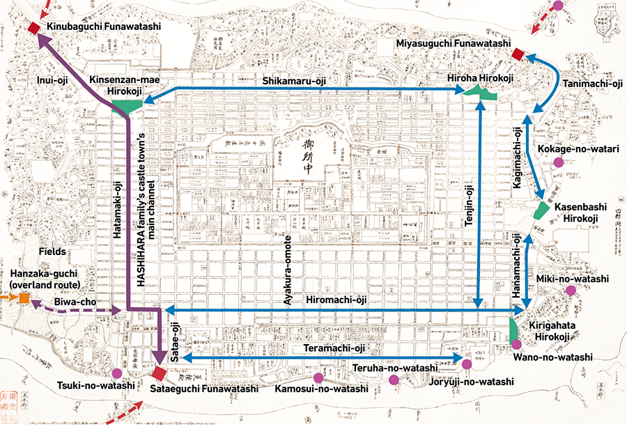
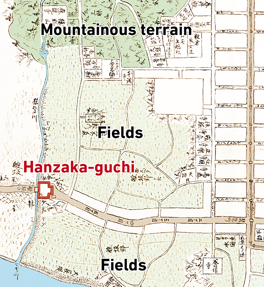
In addition, at the end of Biwa-cho located at the southwestern edge of the town center was a checkpoint known as Hanzaka-guchi, through which goods and people flowed to and from neighboring towns. The area north of Hanzaka-guchi was covered by fields, with the mountainous terrain beyond making it impossible to traverse easily. Therefore, Hanzaka-guchi served as the only overland entrance and exit of the castle town. Since the kanji character for "han" also means "to carry," Hanzaka-guchi is believed to have been the main entrance and exit for the flow of goods.
[Map of the area around Hanzaka-guchi]

Channels linking the castle town with neighboring towns
Two rivers, Shimada-gawa and Momiji-gawa, flowed through the north and south sides of the town center, respectively. A boat crossing called Kinubaguchi Funawatashi was located upstream of Shimada-gawa (northwest side), and a boat crossing called Sataeguchi Funawatashi was located downstream of Momiji-gawa (southwest side). The distances from the opposite shores of these crossings to neighboring towns were marked as "2 ri to Takamuro" and "1 ri to Kusakabe," respectively.
These crossings formed part of the main channels for traveling to neighboring areas, and it is thought that Norinaga positioned the route leading from Kinubaguchi Funawatashi to Sataeguchi Funawatashi via Inui-oji, Hatamaki-oji, and Satae-oji as the town's main road. The highways that encircled the town center served to facilitate the flow of people and goods by land.
In addition, many crossings were placed along Momiji-gawa and along the shore of the Lake Shigun at the eastern edge of the castle town, which are thought to facilitate the flow of people and goods to and from towns across the river by boat.

Also remarkable is the large number of bridges. Although key bridges were set up by the government during the Edo period, it was generally uncommon for bridges to be built over rivers in towns. If a bridge was absolutely necessary, the townspeople had to build it using their own funds. In other words, the presence of so many bridges is proof that many affluent townspeople lived in the castle town.
Because of the excellent ease of movement within the town as well as the well-developed channels linking the town with neighboring towns, the Hashihara castle town was planned such that it could develop into a bustling town where many people gather and where a variety of goods and information are concentrated. Many visitors to Ise could be seen to come and go along the Ise-kaido Road, which passed in front of the house in Matsusaka where Norinaga used to live. It can be inferred that Norinaga was deeply influenced by this and planned the town while envisioning a busy road or highway packed with people and goods.

A town with a vibrant culture
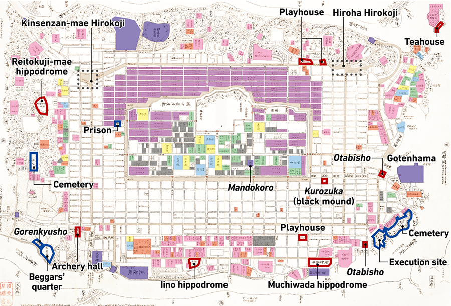
Norinaga had very strong cultural interests, and his diary entries showed that he went to Kyoto to see plays. Cultural facilities such as playhouses which Norinaga enjoyed, as well as archery halls, hippodromes, and otabisho (midway resting points) used during festivals, were placed along the highways of the Hashihara castle town and in the areas with temples and shrines.
In addition, wide roads such as Hiroha Hirokoji and Kinsenzan-mae Hirokoji can be found at the corners of the intersection of highways. It is likely that Norinaga had imagined such areas to be busy public squares where events were held and where people and goods were concentrated.
While many cultural facilities were depicted on the map, there was only one facility with political significance: a mandokoro (administrative body in ancient Japan) located near the imperial palace. The establishment of mandokoro took place until the Muromachi period and was typically not seen during the Edo period. Norinaga's hometown of Matsusaka did not have a daimyo as the castle lord; instead, the castle was guarded by a castle keeper dispatched to the town. Therefore, it is possible that Norinaga did not have a concrete image of politics at the time and did not place much importance on facilities related to politics. At the same time, the map also features facilities such as execution sites, prisons, cemeteries, as well as beggars' quarters and gorenkyusho (Public relief shelter). It is remarkable that Norinaga had a good knowledge of social infrastructure and welfare, which are essential to the framework of a town, and had incorporated these elements into the map.
[Facilities that show Norinaga's interests and preferences and that are necessary for the town]
Incorporation of various scenic spots
On the northeastern lakeside of the map was a scenic spot overlooking Tamatarejima, an island floating on the lake. Tamatarejima was a resort island with a Benzaiten shrine and a teahouse, and could be reached by boat from the opposite shore. This area was home to numerous suburban residences of high-ranking samurai and served as a so-called vacation house district.
In addition, there were several other locations such as Gotenhama that seemed like scenic spots.
Many temples and shrines were also located in the surrounding mountains, with ridge trails that connected them ensuring ease of movement in the same way the highways did in the town center. It can be inferred that this was also inspired by Kyoto, where it is possible to visit many temples and shrines at one go.

4. A peaceful town without war
Defense of the imperial palace with no consideration of war
From the Genealogical Table of the HASHIHARA Family, the project team deduced that the reign of HASHIHARA Nobumasa took place during the peaceful Edo period. Of course, the castle town map also painted the picture of a town in peaceful times.
There were seven gates around the imperial palace, a very large number compared to other castle walls of the same scale (refer to [Reading the townscape axes]). Even larger castles such as Osaka Castle and Nagoya Castle usually have only three or four gates. The moat was only around seven meters wide, and there were no masugata (enclosure squares) or other defensive structures around the gates, making them easy for the enemy to attack. Furthermore, even though the residences of lower-ranking samurai were located on the north side of the castle, the interior of the imperial palace was fully visible from the mountains to the north, which raises questions from the standpoint of defense.
Wide streets for a prosperous life
As mentioned previously, the town center of Hashihara consisted of straight streets, and it had almost no crisscrossing streets or right-angled streets that were characteristic of castle towns. Therefore, in the event of war, the enemy would be able to reach the castle walls in no time.
The width of the streets was also designed to be rather wide for that period. While Minami-oji and Nishi-oji, which surrounded the palace, were 20 to 36 meters wide, the width of most streets had been standardized to be in the range of 8 to 17 meters, which was wider than streets in castle towns in general.
This suggests that Norinaga had designed the Hashihara castle town to be a safe town without any concerns of war. And by securing wide and comfortable spaces, he may have presented the plan for a town that was more attentive to a high quality of life than defense by facilitating the flow of people and goods.
[Width of the streets]
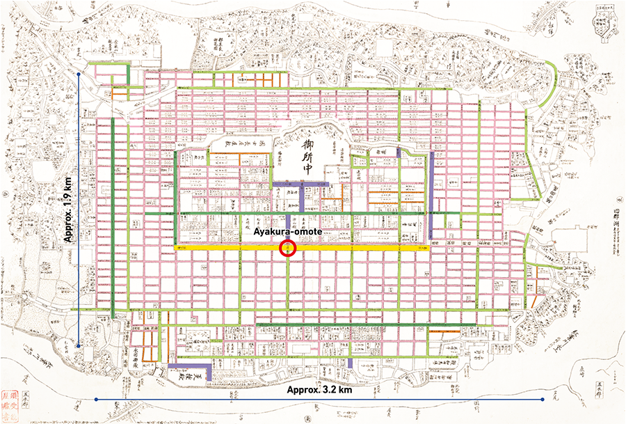

[Column] Ayakura-omote and the residence of the former ruler's son
There was a large gate called Ayakura-omote at the front of the citadel area. Only the street in front of Ayakura-omote is unnamed and was connected to the main street of the citadel area, suggesting that Ayakura-omote was the most important gate. Entering the citadel area from Ayakura-omote would bring one to the bending main street leading to the imperial palace.
Interestingly, Nobumasa had made the son of the former ruler KATSUYAMA (Nagamori-dono) his vassal, whose residence could be found at the corner of the bend. This means that when one entered the citadel area from Ayakura-omote, they would first see the residence of Nagamori-dono, and upon making a turn at the bend, the magnificent castle of the current ruler would come into view in the background. The purpose of this arrangement may have been to strongly impress upon passersby that the current ruler was the HASHIHARA family, with Nagamori-dono merely its vassal.
It is possible that Norinaga made these arrangements in various parts of the map as most of the information in the genealogical table was perhaps already in Norinaga's mind. Although there is no means to verify if this hypothesis is correct, one of the most exciting aspects of this project is that by reading the map and the genealogical table alongside each other, we can let our imagination run wild and get as close as possible to Norinaga's thought process.
- The first page
- Previous page
- page 1
- page 2
- Current page: page 3
- page 4
- page 5
- 3 / 5
- Next page
- The last page
The issue this article appears
No.64 "Map"
Maps invite people into the unknown, and people get thrilled when presented with one―a simple sheet of paper.
From maps carved into rocks and historically ancient maps used in old times, to digital maps made by satellite in the modern era, we humans have been perceiving the world through a variety of maps.Not only do they help us visualize the world’s shape and overall appearance, but sometimes imaginary worlds are also constructed based on them.
In this issue showcasing various maps, we examine how people have been trying to view the world and what they are trying to see.In the Obayashi Project, we took on the challenge of deciphering and reconstructing in three dimensions a fictional city map called the Hashihara Castle Town Map (Hashiharashi Joka Ezu) drawn by Kokugaku scholar MOTOORI Norinaga when he was nineteen years old.
(Published in 2025)
-
Gravure: Is this also a map?
- View Detail
-
What Is a Map?
MORITA Takashi
(Professor Emeritus, Hosei University) - View Detail
-
The Frontiers of Maps: From the Present to the Future
WAKABAYASHI Yoshiki
(Professor Emeritus, Tokyo Metropolitan University) - View Detail
-
Visible World, Invisible World
OTA Akio
(Professor, Department of Visual Communication Design, College of Art and Design, Musashino Art University) - View Detail
-
The Dreams and Solitude of a Youth Who Drew Maps
YOSHIDA Yoshiyuki
(Honorary Director, Museum of Motoori Norinaga) - View Detail
-
OBAYASHI PROJECT
Deciphering the Hashihara Castle Town Map: The Imaginary Town of MOTOORI Norinaga
Speculative Reconstruction by Obayashi Project Team
- View Detail
-
FUJIMORI Terunobu’s “Origins of Architecture” Series No. 15: Japanese Datum of Leveling Monument
FUJIMORI Terunobu
(Architectural historian and architect; Director, Tokyo Metropolitan Edo-Tokyo Museum; and Emeritus Professor, University of Tokyo) - View Detail
-
Interesting Facts About Maps
- View Detail