Publication of the public relations magazine Obayashi Quarterly No. 64, "Map": Deciphering MOTOORI Norinaga's Imaginary Town in the Hashihara Castle Town Map
-
Others
OBAYASHI CORPORATION (Headquarters: Minato-ku, Tokyo, President: SATO Toshimi) has published the 64th issue of its public relations magazine Obayashi Quarterly entitled "Map." Since its first issue published in 1978, Obayashi Quarterly has been examining what we humans have built in the past, and what we can build in the future, taking the times and cultures into consideration. In this issue showcasing various maps, we examine how people have been trying to view the world and what they are trying to see. Furthermore, in the Obayashi Project, we took on the challenge of deciphering the map of a fictitious town called the Hashihara Castle Town Map (Hashiharashi Joka Ezu) drawn by the Edo-period Kokugaku scholar MOTOORI Norinaga when he was nineteen years old, and attempted to reconstruct it in three dimensions. OBAYASHI CORPORATION regards the publication of Obayashi Quarterly, which examines the culture related to construction, as part of its socio-cultural activities, and actively takes up important themes such as the environment, information, and disaster prevention.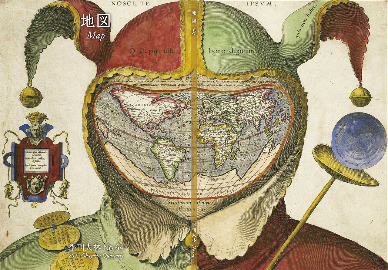
About Obayashi Quarterly and "Obayashi Project"
From the first issue featuring "Pyramid" published in 1978 to the present, Obayashi Quarterly aims to be a public relations magazine that examines the civilization and culture mankind has built through the perspective of construction, while exploring the future society. During that time, many researchers and experts from in and outside of Japan have contributed, making the magazine a highly acclaimed public relations journal that is academic and unparalleled.
The most pronounced of Obayashi Quarterly is the article "Obayashi Project," where the project team takes on the challenges of restoring and assessing historical buildings, and planning buildings and towns that will contribute to the future society. The article presents the processes and results of the projects.
Examples of restoration projects include "The Main Shrine of Ancient Izumo Taisha," "Rokujo-in, the Residence of the Hikaru Genji (built in Shinden-zukuri style) ," "The Great Library of Ancient Alexander," "The Hall of the Great Buddha Built by Toyotomi Hideyoshi." Examples of ideas for the future are seen in the "Mars Habitat Plan," "Jelly Seismic Isolation Concept to Isolate the Entire City," "Space Elevator Construction Plan," "Smart Water City Tokyo Construction Plan," "LOOP50: City Living Together with Forests," and "COMPACT AGRICULTURE: a Recycling-based Agriculture Created with Technologies." In addition to demonstrating the high technical levels of the Obayashi Group, the articles also showed fascinating and profound aspects of construction, becoming hot topic as opportunities to deepen understanding of construction culture.

Obayashi Quarterly No. 64, "Map": Overview
Maps invite people into the unknown. From maps carved into rocks and historically ancient maps used in old times, to digital maps made by satellite in the modern era, we humans have been perceiving the world through a variety of maps. Maps visualize not only the world's shape and overall appearance, but also a variety of information linked to specific locations. Sometimes, imaginary worlds are also constructed based on these maps.
In this issue showcasing various maps, we examine how people have been trying to view the world and what they are trying to see. Furthermore, in the Obayashi Project, we took on the challenge of deciphering the map of a fictitious town called the Hashihara Castle Town Map (Hashiharashi Joka Ezu) drawn by the Edo-period Kokugaku scholar MOTOORI Norinaga when he was nineteen years old, and attempted to reconstruct it in three dimensions.
■Main contents
Featured Photos: Is this also a map?
This article gathers and showcases surprising examples of maps beyond what we would typically consider "maps" from around the world and throughout history, including illustrations depicting legends and tales, road maps that resemble picture scrolls, maps projected onto polyhedral surfaces, and works of art.
What Is a Map?
MORITA Takashi (Professor Emeritus, Hosei University)
Maps can take a variety of different forms, including drawings on paper or in digital spaces, and even mental images in the space before they are substituted by something else. Drawing on a variety of examples, this article analyzes the representations of maps that stimulate the imagination, explores why maps are so interesting, and considers the question of "what is a map."
The Frontiers of Maps: From the Present to the Future
WAKABAYASHI Yoshiki (Professor Emeritus, Tokyo Metropolitan University)
Rapid informatization and digitalization have permeated various domains of society and dramatically altered the world of maps. This article discusses in detail the changes in post-digitalization maps by looking in turn at the methods of collecting and creating geospatial information, cartographic representations, and the uses of maps, and examines the issues and future of maps while taking into account what has remained unchanged.
Visible World, Invisible World
OTA Akio (Professor, Department of Visual Communication Design, College of Art and Design, Musashino Art University)
How have maps represented the "world"? Some maps have sought to depict "invisible worlds" through not only topography but also time, space, perception, and cognition in various ways. This article explores new possibilities for maps by challenging the limit of maps and tracing the evolution of depiction.
The Dreams and Solitude of a Youth Who Drew Maps
YOSHIDA Yoshiyuki (Honorary Director, Museum of Motoori Norinaga)
As a great Kokugaku scholar, what did MOTOORI Norinaga, what kind of knowledge did MOTOORI Norinaga have and what did he take an interest in as a young man? Drawing on Norinaga's background, writings from his youth, and the documents and drawings he penned, FUJIMORI Terunobu's "Origins of Architecture" Series No. 15: Japanese Datum of Leveling Monument aspirations and struggles, as well as the significance of the "Hashiharashi Joka Ezu," his drawing of a fictitious town.
FUJIMORI Terunobu's Origins of Architecture Series No. 15: Japanese Datum of Leveling Monument
FUJIMORI Terunobu (Architectural historian and architect; Director, Tokyo Metropolitan Edo-Tokyo Museum; and Emeritus Professor, University of Tokyo)
As part of efforts to survey the entire Japan during the Meiji era, a reference point in a corner of the site of the former Army Ministry was used to determine height (elevation) in Japan's territory. The Japanese Datum of Leveling Monument, a small stone building in the style of an ancient Roman temple, was built at that location. This article traces the ideas of its designer, SATACHI Shichijiro, and offers insights into the spirit of that era and the significance behind the monument's design.
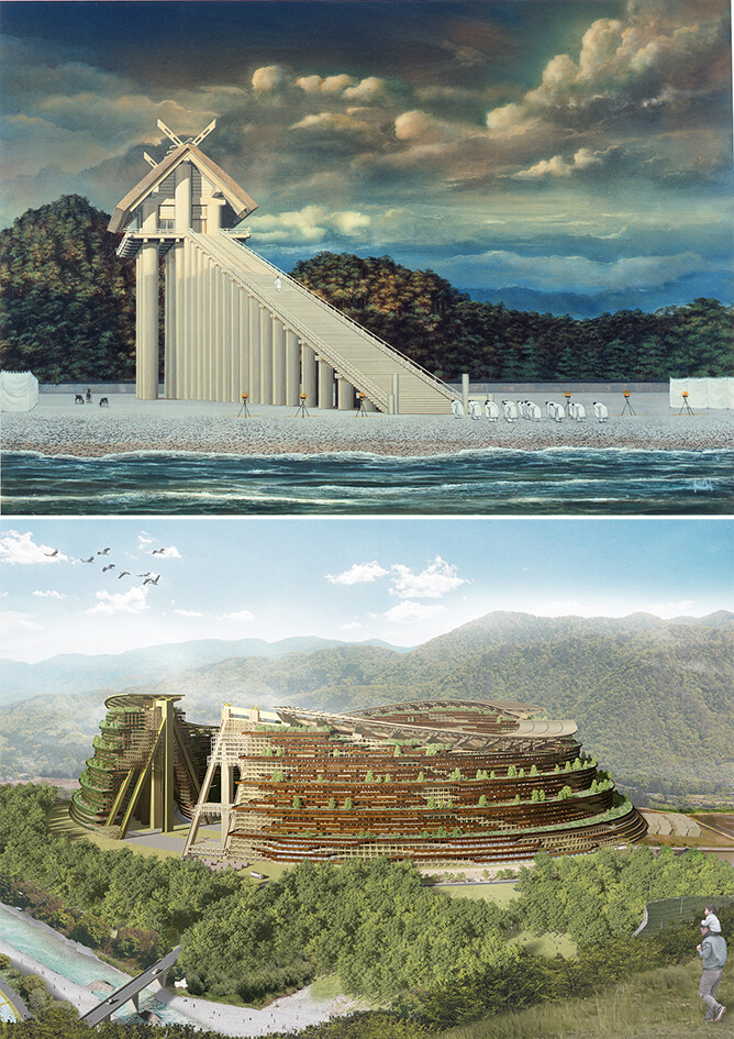
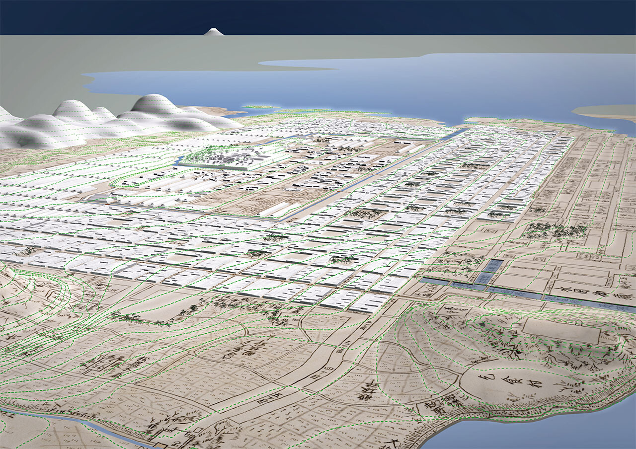
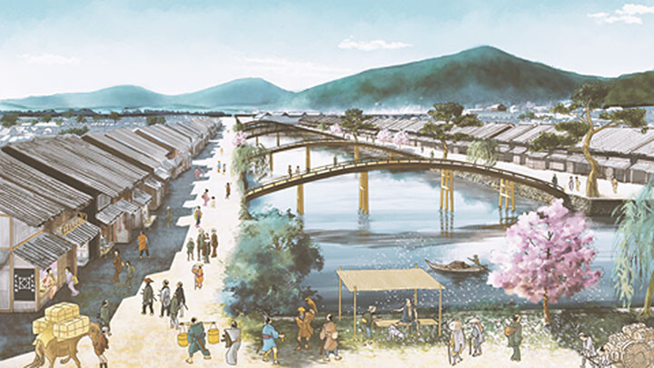
Obayashi Project: Deciphering the Hashihara Castle Town Map: The Imaginary Town of MOTOORI Norinaga
Speculative Reconstruction by Obayashi Project Team
MOTOORI Norinaga was an Edo-period intellectual giant known for his meticulous study of the classics. The Hashihara Castle Town Map (Hashiharashi Joka Ezu) is a map of a fictitious ideal town that he drew along with the Genealogical Table of the HASHIHARA Family (Hashiharashi Keizu ) at the age of nineteen. The map depicts the entirety of a castle town surrounded by natural terrain, and it contains the names of people in the genealogical table. The map also shows many shrines and temples in the surrounding mountains, with rivers and bridges having names derived from the classics, suggesting a culturally vibrant town. What was the significance of this map for Norinaga?
This project closely examines the Hashihara Castle Town Map and visualizes the process of deciphering the map. Its goal is to create a three-dimensional reconstruction of the town imagined by the young Norinaga and explore the ideals he envisioned.
-
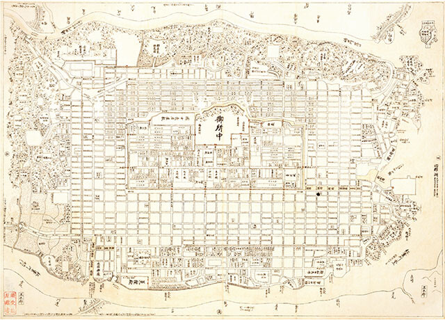
The Hashihara Castle Town Map (Hashiharashi Joka Ezu) 517×720mm Museum of Motoori Norinaga collection
-
For further press inquiries, please contact:
Public Relations Division , Corporate Communications Department ,
OBAYASHI CORPORATION
Contact us